
See the whole picture
Act instantly.
In addition, large-scale operations often span multiple geographical sites and feature thousands of cameras, sensors, audio devices, doors, and other input devices.
Staying on top of it all can sometimes feel like an impossible task. With Smart Map, we not only make it possible, we also make your job easier too.

Meet Smart Map in XProtect
WITH SMART MAP, YOU CAN...

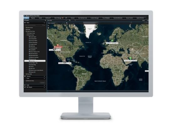
Visualize entire installations
Remembering where each camera is in large, multiple-location installations is almost impossible. With Smart Map, you get real-time visualizations of the installation. Each device displays its exact location, status, and fields of view.

Gain situational awareness
Smart Map helps you see your entire operation and quickly identify potential threats or emergencies. Alarms are displayed directly on the map, with live or recorded footage just a click away, so you can take immediate action.

Navigate effortlessly
Smart Map allows you to easily navigate between different sites and locations via Quick Links placed directly on the Smart Map. This functionality enables you to quickly navigate around any operation regardless of size.
It’s easy to populate the map with cameras and navigation links using an easy drag-and-drop, and point-and-click definition of the cameras, camera field of view, location links and quick links.


Want to know more?
Video
How Smart Map makes security operators' lives easier

Feature Brief
Everything you need to know about Smart Map - short and sweet!

Demo Video
See for yourself -Smart Map in action